
- 275
- 4 378 663
Geospatial School
United States
Приєднався 12 жов 2011
Using open-source programming resources for GIS and data science. A large focus is placed on the QGIS software, including QGIS Python (PyQGIS) scripts, plugins and development. Data science and data analysis are also common topics. Along the way we also cover topics in Python, R and other programming languages.
Make Hundreds of Maps in Seconds with QGIS (How to Automate Map Layouts and Data with Python)
Automate map layouts and data visualization in QGIS. This tutorial will demonstrate how to use Python code in QGIS to automate map creation. It allows you to create hundreds of maps in seconds!
Donate to Give Internet: giveinternet.org/opensourceoptions
Donate to Give Internet: giveinternet.org/opensourceoptions
Переглядів: 1 263
Відео


Tree Heights from Lidar with QGIS (Create a Canopy Height Model)
Переглядів 1,4 тис.2 місяці тому
Create a canopy height model from lidar data in QGIS. Lidar makes it possible to calculate tree heights. This tutorial will demonstrate how to do this using the built-in QGIS tools. Donate to Give Internet: giveinternet.org/opensourceoptions Website: geospatialschool.com

Stream and Analyze Point Clouds in QGIS without Downloading (You can't do this with ArcPro!)
Переглядів 2 тис.2 місяці тому
Use QGIS to stream point clouds from the 3DEP online repository. QGIS supports streaming point clouds without downloading the underlying data. You can also filter these point clouds and create derivatives from them without downloading.

How to use Visual Studio Code as your Python IDE
Переглядів 4392 місяці тому
Visual Studio Code is the ultimate IDE for developing with Python because it is free, open source, and has tons of functionality! Learn how to set it up and use it in this tutorial. Free course: geospatialschool.com

Use QGIS to DOWNLOAD MAP TILES
Переглядів 1,2 тис.3 місяці тому
From QGIS you can load many different basemaps. Did you know there are some base maps you can also download? This tutorial will demonstrate how you can download multiple base maps using the QGIS Map Tile Loader plugin. Free GIS and Programming Courses: geospatialschool.com Website: opensourceoptions.com

QGIS BASEMAPS: the ULTIMATE GUIDE
Переглядів 5 тис.3 місяці тому
There are HUNDREDS of base maps you can add to QGIS for FREE. This tutorial covers 3 different methods to add basemaps in QGIS. You'll learn how to add base maps with the Quick Map Services plugin, the HCMGIS plugin, from WMS/WMTS source URLs, and from XYZ URLs. This is so easy! Free GIS Courses: geospatialschool.com/free-courses Learn-more: opensourceoptions.com

Better Python PACKAGE MANAGEMENT with MAMBA
Переглядів 6853 місяці тому
Get more reliable and faster Python package installation with the Mamba package manager. This tutorial demonstrates how to install Mamba with conda (note, this is not the recommended installation method). Learn More: opensourceoptions.com/how-to-install-mamba-for-python/ Free GIS Courses: geospatialschool.com
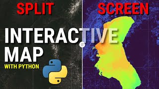
SPLIT-SCREEN MAP with PYTHON: SWIPE to change the map layer!
Переглядів 5584 місяці тому
Use the Python leafmap package to create a split-screen map inside of a jupyter notebook. With a split-screen map you can show two different data layers on the same map and swipe to reveal or hide one of the layers. This is a great way to visualize data for presentation or for analysis. Get the code here: geospatialschool.com/lessons/leafmap-split-screen-map-in-jupyter-notebooks/ or here: opens...

DEEP LEARNING in QGIS: Image Segmentation (Aerial and Satellite) with the DEEPNESS Plugin
Переглядів 8 тис.4 місяці тому
The QGIS Deepness Plugin allows you to perform deep neural remote sensing directly in QGIS with pre-trained models. This tutorial demonstrates how to install the Deepness plugin, download pre-trained deep-learning models, and apply existing models to aerial and satellite images. This is one way you can apply Geo AI directly in QGIS. FREE GIS Courses: geospatialschool.com Website: opensourceopti...
AUTOMATICALLY DIGITIZE map features in QGIS with this PLUGIN
Переглядів 3,3 тис.4 місяці тому
Bunting Labs has developed an automatic digitization and vectorization tool. This tool uses artificial intelligence and deep learning to automatically trace map features. The automatic tracing tool is a great example of how useful GeoAI can be to automate repetitive tasks. There is QGIS plugin available for the automatic digitization tool. To use the plugin you'll need an account with Bunting L...
Spatial Data Science to Analyze Rivers with Python
Переглядів 7594 місяці тому
Apply Python and data science to analyze river topography and identify where flooding may occur. This tutorial will demonstrate how to perform interpolation on spatial raster data. We'll also pull in river information from open street map and integrate raster and vector data for our analysis. Code: opensourceoptions.com/creating-rems-and-detrended-dems-with-python/
Animations in minutes! Easily Create Animated Heatmaps with Microsoft Excel
Переглядів 3855 місяців тому
With Microsoft Excel, it's super easy to create animated maps. This tutorial will show you how to animate heatmaps to create a video you can share. We'll use Excel's 3D Maps functionality to display points and animate them through time.
This is so EASY! Make a heatmap from points with Microsoft Excel
Переглядів 9295 місяців тому
Microsft Excel 3D Maps makes it so easy to create awesome maps and visualizations from point data. All you need is a list of points and you can create a heatmap. This video will walk you through the process of creating a heatmap in Microsft Excel with elk location data from GPS collars (point data).
Easiest map EVER! How to make a map with Microsoft Excel
Переглядів 4065 місяців тому
Microsoft Excel makes it SUPER EASY to create a map. Just enter the location and then the data. That's it. Now you can create a map. This tutorial will show you just how easy it is to create a map with Excel.
How to Make a Map with QGIS (it's EASY!)
Переглядів 6466 місяців тому
It's easy to make a map with QGIS. Learn how in this tutorial. You'll learn how to add data, change data symbols, crate a map layout, add titles, legends, scalebars, etc., and export your map as an image or PDF.
You need to use the GeoPackage file format!
Переглядів 1,7 тис.6 місяців тому
You need to use the GeoPackage file format!
QGIS Charts and Diagrams: Make Next-level Maps!
Переглядів 6888 місяців тому
QGIS Charts and Diagrams: Make Next-level Maps!
3D Surface form a Point Cloud with QGIS
Переглядів 1,4 тис.8 місяців тому
3D Surface form a Point Cloud with QGIS
Elevation Profiles and Cross-Sections in QGIS
Переглядів 3,7 тис.8 місяців тому
Elevation Profiles and Cross-Sections in QGIS
Create a true-color lidar point cloud
Переглядів 7578 місяців тому
Create a true-color lidar point cloud
Create, Edit, and Symbolize Shapefiles with QGIS
Переглядів 5068 місяців тому
Create, Edit, and Symbolize Shapefiles with QGIS
Easy Address Geocoding: Addresses to Points with Felt
Переглядів 5559 місяців тому
Easy Address Geocoding: Addresses to Points with Felt
Create REMs in QGIS for Flood and River Analysis (Detrended DEMs)
Переглядів 5 тис.9 місяців тому
Create REMs in QGIS for Flood and River Analysis (Detrended DEMs)
Awesome Lidar Visualizations with QGIS 3D View!
Переглядів 3,3 тис.10 місяців тому
Awesome Lidar Visualizations with QGIS 3D View!
Download and Display Seamless Lidar Point Clouds for the United States
Переглядів 60710 місяців тому
Download and Display Seamless Lidar Point Clouds for the United States
The EASIEST Way to Install Python for Windows 11 (also works for Mac and Linux)
Переглядів 23410 місяців тому
The EASIEST Way to Install Python for Windows 11 (also works for Mac and Linux)
Clip Raster Layers with Python and GDAL
Переглядів 3 тис.Рік тому
Clip Raster Layers with Python and GDAL
Hello. I get this message, when run this code (No module named 'GDAL'). However, i install GDAL, in Jupiter notebook. Please Help Me. Thanks.
@Geospatial School Hi! I'm working through the tutorial, and I've had some trouble with the relative file path for "vrt_fn". I'm either getting an error that says "RasterioIOError: my.vrt: No such file or directory" or "Permission denied", though I'm running VSCode as an administrator. I've named my current working directory, "mapbooks", which contains the .ipynb file and "S2A_MSIL2A_20240307T190231_N0510_R013_T10TFR_20240308T010347.SAFE.zip". What would the relative file path be given my file structure; seems like I've tried everything, but can't get the VRT file to be created or accessed via the file path. Thanks!
This is exactly what I want but, is there a way to download all the jpeg images? I'm making a 2D flight simulator and I need the individual tiles. Do you know how? I could just divide them after but, this makes it easier since I will be doing the world.
Sorry, but this does not work despite EXACTLY following the steps you suggested.👎
Exactly what I was looking for!😁
But how do you also delete away the square from the original raster so it doesn't overlap?
Hi, Is there a group by and summarize possibility on vector attribute table using pyqgis?
thank you for this tutorial. i don't have Point cloud conversion or data managment or extraction in my processing toolbox. i'm on mac. any solution? thanks
Hello, I'm not able to find the course. Would you be able to provide another link if possible? Thanks in advance.
Perfect tutorial! Special thanksss❤
Awsome, ty
Great explanation. These channel migration visualizations have wrinkled my brain for a while now. Looking forward to playing around with this.
Dear Sir, thanks for sharing your video. I have a very dumb question here. Do I need to keep Python/Anaconda (installed) in my laptop while using VS Code (assuming I have done steps you've shared above)? Or I may actually uninstall Python/Anaconda after VS Code setup done? Hope to hear from you, thanks in advance.
How accurate are these DTM/DSM heights if you actually measured the tree or any object your measuring?
How do I get the shape files
3 years later and its still helping out people like me! Thank you for taking your time to make this video
Thank you for your serial tutorial video! It helps a lot! But I am wondering if it should be "mask" instead of "maskarray", because In the function of np.ma.MaskedArray(), I think there is a keyword named "mask" but not "maskarray". I tried to run the code as what you have done herer and got an error: an unexpected keyword argument 'maskarray'.
Thank you for the nice explanation. I had difficulty with that black area around my clipped raster.
i know i’m years late but i really appreciate you leaving your errors in the video!
I had no idea!
Thanks for this Video, i have the Problem that i have always Network timeout when i add the opentopomap. Do you have any slolution for this Problem ?
Sorry, no
nice video...but how could you upload the point cloud into QGIS very fast...i have point cloud data from my own Lidar, about 2 million points...too heavy to upload...hope you can give some tips...thank you
You can just add it to QGIS. The data manager has an option to add a point cloud. You'll have all the same functionality. 2 million points shouldn't be too much for QGIS as long as your system meets minimum requirements.
Impressive! I'm only one year into GIS and very very far from being this proficient. How did you start to learn to Python in QGIS/GIS in general. Do you have any tips?
The biggest thing is to start. Start writing code and making mistakes. The more mistakes you fix the faster you'll learn. I have some courses at GeospatialSchool.com that can help you get started if you like. There's even a free Python quick start course
Hi! Does this method also work using SAR data? I do not have LiDAR data for my area of interest. Thank you in advance.
It will work with any elevation data, though the results may vary depending on accuracy and resolution
@@geospatialschool Thanks for the answer!
Thank you so much, this thing about "specified nodata" save my life, was kinda frustrating the images with the black parts
Glad it helped!
Daaaaaaaang. It worked surprisingly well on .45m imagery. Thanks for sharing!
Great to hear!
Thank you, this was really useful. I find your teaching style really user friendly! I followed the tutorial as I don't have the required extensions in ArcGIS, so doing this in QGIS was great. Do you have any tips on converting the output to vector whilst maintaining the ID classifications? Rather than converting to vector each created polygon just having a random ID which you then have to classify? Also, and this might be an entirely different video, but do you have any info on machine learning? What I mean is this is great to classify pixels, but obviously a reservoir and a river might end up as the same output due to both being same pixel value/blue. But is there a way to teach it to say this is a reservoir, based on pixel values and the shape, as opposed to this being a river, which has same or similar pixel value, but different shape? I haven't used QGIS in a while, so dusting off the cobwebs!
Thanks! So you're looking for object identification with rivers vs lakes. That's really an entirely different (more difficult) problem because the spectral signature alone won't give you that information, you need spatial context and shape and those things are scale dependent. You should be able to convert the raster to vector and maintain the classified identifiers.
@@geospatialschool Yes exactly, I feel like this is more of a deep learning/object detection/machine learning analysis rather than image classification. I will dig into it some more and see what is possible. Thanks
est ce que gdal est dans la machine ou bien est dans anaconda car depuis je cherches a installer par osgeo4w mais depuis sa marche pas
Do you know how is it possible to get the manually selected features ?
Yes it is
Para ejecutar LLaMA 3 en tu ordenador, aquí tienes los requisitos de hardware: Modelos Pequeños (7B - 13B parámetros): RAM 16-32 GB, CPU Intel i7/i9 o AMD Ryzen 7/9, GPU opcional de 8 GB VRAM (NVIDIA RTX 3060). Modelos Medianos (30B - 65B parámetros): RAM 32-64 GB, CPU Intel i9 o AMD Ryzen 9, GPU de 16 GB VRAM (NVIDIA RTX 3080/3090). Modelos Grandes (175B parámetros y superiores): RAM 64-128 GB, CPU Intel Xeon o AMD Threadripper, múltiples GPUs con 24 GB VRAM cada una (NVIDIA A100, RTX 3090).
Hi, do you know if is possible operate a confrontation between attributes of the same layer or different?
Thank You for such a clear and precise tutorial! it saved me a lot of time and effort. Thanks!!
Glad it helped!
Thanks!
Thank you! Hope you found it helpful!
How to interpolate multiple.nc files in python Jupytrr notebook and get a single file in .nc format? Currect resolution of my gridded data is 0.25*0.25 degree i want to interpolate it upto 0.01*0.01 degree. Can you help me by code?
Hello, thanks for the video. I have a question please, why I don't have python3 -m in the GDAL/OGR console call, thank you
Thank You very much, is there any way to run queries in QuickOSM in the python console
a life saveer thank youuuu
Having access to the source code would be very helpful!?
😔
Could you provide your dataset(s)? It would be helpful to have layers and attribute tables that match yours. Being new to QGIS, and using a shapefile for rivers from another source, that doesn't have the attributes your layer has, makes it cumbersome. GREAT STUFF! Thank you so much for publishing your videos!
I provide all my datasets with step-by-step instructions in the full course. You can access it here, if you're interested: geospatialschool.com/courses/qgis-python-scripting-with-pyqgis/
@@geospatialschool OK. Thanks for getting back to me.
Oh no. It doesn't work for the Philippines T.T
Whoaaaa! That's so good. Thank you!
Glad you like it!
Thanks for your video(s). I just started learning about processing point cloud data in qgis and your channel has been helpful for sitting next to a pro and getting guidance. Great job walking us through a complex task. Thank you. I would love to make canopy model maps like this video. One issue I am facing while using 3.34 is that the processing toolbox does not contain -Point cloud conversion folder or any of it's contents. Is there a step that is needed to get those in the toolbox? I am stalled out there and cannot proceed.
Interesting. I thought the point cloud tools were standard with 3.34. Are you using the long-term release? If you're not using the LTR or don't need to use it then just upgrade to 3.36. That's the version I used
@@geospatialschool Thanks! yea it's 3.34 LTR. Appreciate the guidance and sharing your release numbers
@@geospatialschool I just dl and open 3.36 and the Point cloud conversion folder is not there. Using MacOS sonoma. Weird
That is strange. Maybe something with Mac?
@@geospatialschool discovered the issue. The qgis dl on the website for mac doesn't provide point cloud. Had to dl thru macport
Hey there! Thanks for reviewing this plugin! ESRI satellite tiles may not be avaliable on some zoom levels. Same can be seen if you load a tms layer in QGIS and zoom close to area.
Thanks for the info!
This is the perfect answer for what I was asked by a coworker. Thanks!
Glad it was helpful!
there are any object based classification model for Landsat ?
Object-based classification is usually implemented with high res data where objects (like trees or buildings) are composed of many pixels. Landsat is coarse enough that pixel-based methods are generally used, though I'm sure there are some object based approaches if you look around
Seems like their download links are broken. I can't get any of the laz files 🙁
Check out the USGS lidar explorer. It was working yesterday
thank you for posting this video, my professor didn't tell me how to install this thing, it has helped me save a lot of time
Glad I could help
What version of the program do you have?
3.36
Very nice explained!! That helped me so much with my thesis! Thank you a lot!
Glad it helped!